The Seaview Survey Project (2012-18) surveyed coral reefs in 23 countries and took more than one million images to support conservation and research. The resulting dataset provides a visual documentation of reef health around the world.
Learn more about this project and discover the published open access datasets available online.
About the Seaview Survey Project
Why we need reef data
- Coral reefs are in conservation crisis due to the effects of climate change, unsustainable fishing and tourism practices, poor land use, pollution, and invasive species. 70-90% of reefs globally may be lost by 2099.
- Reefs are difficult to monitor. They are often inaccessible and remote, and are not readily observable using satellite technologies.
Having a measure of their abundance and ‘health’ is essential for understanding how reefs are changing and for informing conservation action.
The project
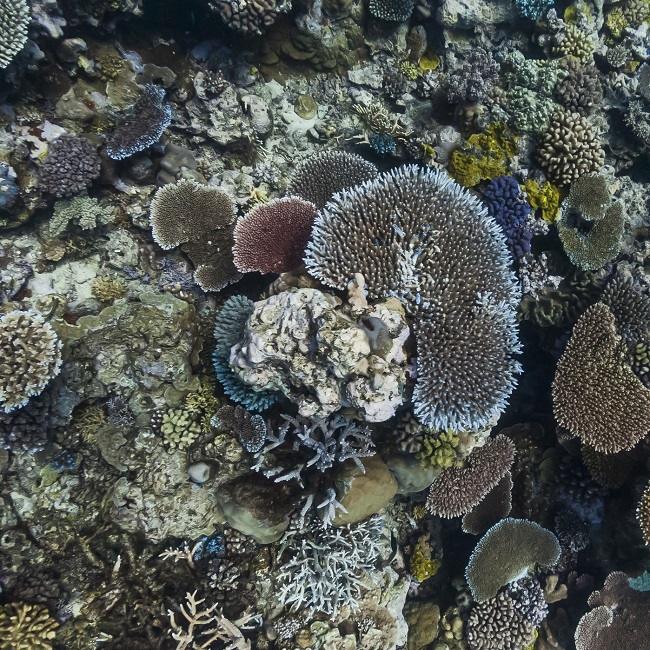
The Seaview Survey project conducted 860 detailed scientific surveys of shallow reefs (10 metre depth) in the Atlantic (mainly Caribbean), the Indian Ocean, the Pacific Ocean, the Great Barrier Reef, and South-East Asia.
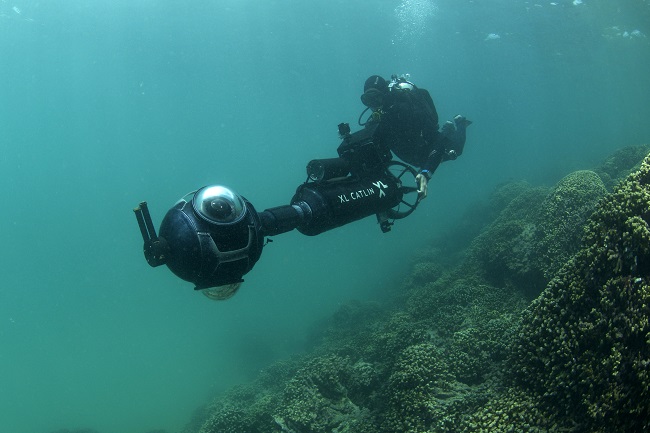
Using innovative technology including custom 360o underwater cameras and machine learning algorithms, the Seaview Survey project was able to collect and classify over one million georeferenced coral reef images along transects (sections at regular intervals) with an average length of approximately two kilometres.
Project outputs
The University of Queensland has made the datasets open access in UQ eSpace. This includes:
- Over one million standardised images (quadrats covering approximately 1m2 of sea bed)
- Human-classified annotations that can be used to train and validate image classifiers
- Benthic (underwater) cover data derived from the photo-quadrats
- Raw images (covering 360°) from which the photo-quadrats were derived.
Many research publications, available in UQ eSpace, have utilitised this dataset. The dataset will support further research in coral reefs conservation, the impact of climate change, and the sustainability of marine environments.
Details on the survey locations and links to the data files for download are found in the map below.
Our partners
The project was undertaken principally by The University of Queensland. The principal funder was the XL Catlin Group (now AXA XL) with additional funding by Vulcan Inc., Academica Sinica, and the Australian government. Communication and outreach by Underwater Earth. Custom camera and sensor system developed by Underwater Earth and adapted for science by The University of Queensland
Research with impact
Scientific Value
The XL Catlin Seaview Survey is one of the largest underwater stock-takes of outer reef slope coral reefs ever undertaken.
Using the technologies for rapidly assessing the state of coral reefs at kilometre-scales provides new opportunities to look at a range of reef characteristics and to understand the patterns of reef development at increasingly larger scales.
This extensive, detailed survey data provides important opportunities for understanding where and how coral reefs are changing, and for understanding patterns of variation in coral reef composition and structure.
Conservation Benefits
The Seaview Survey provides a baseline assessment of the reef state prior to catastrophic loss and, when the surveys are repeated over time, a formal assessment of the change in reef state.
This information informs conservation by helping us to understand how reefs are changing, and what reef states to aim for using conservation interventions. In addition to targeting conservation efforts, the Seaview Survey provides a critical foundation for assessing how reefs are changing due to ocean warming, acidification and other pressures.
Protecting our global reefs
The innovative use of technology in this project provides new opportunities to look at a range of reef characteristics. Now it is possible to understand the patterns of reef development at increasingly larger scales - enhancing our ability to investigate issues such as differential survivorship, and changes in community structure and habitat structure.
In combination with other large-scale studies of coral reefs these surveys help to develop global plans for coral reef conservation. For example, a recent application of this information has been in designing a global conservation strategy in the context of climate change and ongoing local stresses (Beyer et al 2018; Hoegh-Guldberg et al. 2018).
The combination of sophisticated modelling and rapid survey techniques presents improved opportunity to inform conservation action at a global scale that is more robust to uncertainties in climate impacts on reefs.
The conservation project in partnership with World Wildlife Fund and several other conservation NGOs is planning to use this information to target conservation efforts that reduce local stresses (on these key climate sites) and thereby improve the survivorship of these coral reefs in the future.